The Zealand River: A Blueprint for Failure and an Opportunity for Success
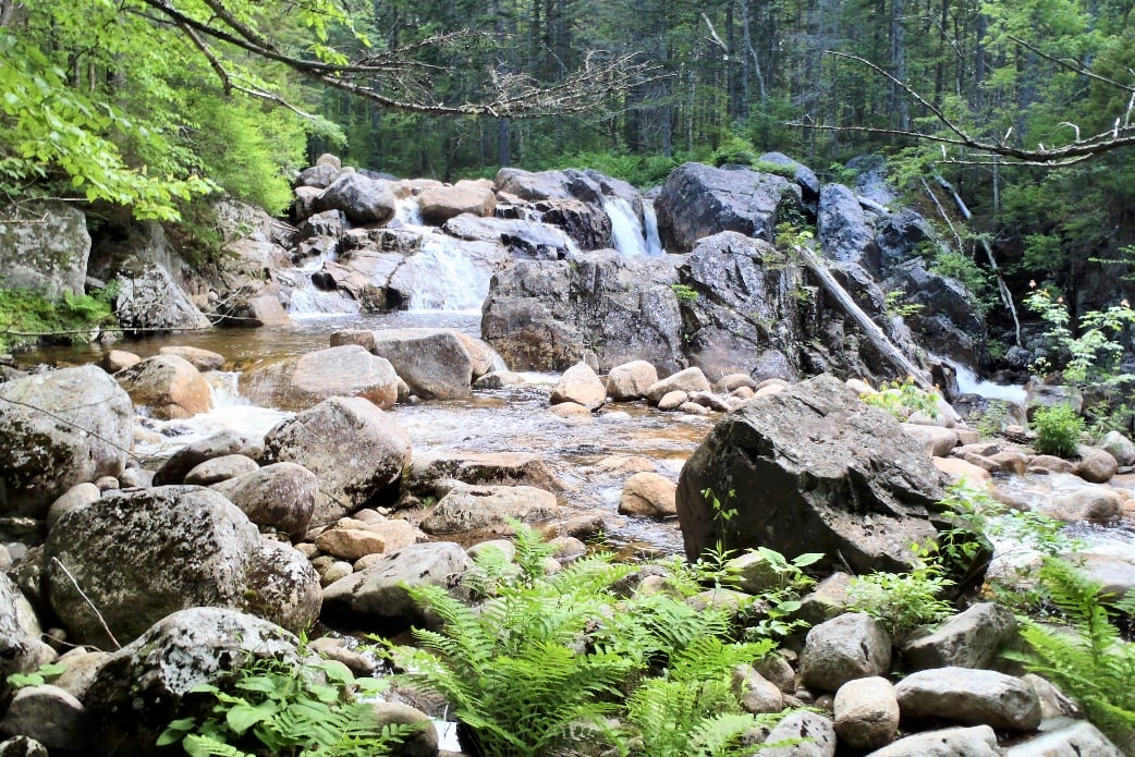
The Zealand River at its best.
Editor’s Note: This is the fourteenth article in our series on fly fishing conservation. This series appears with the support of Epic Fly Rods.
Deep in New Hampshire’s White Mountains lies one of the most beautiful rivers you will ever see. To call it the quintessential New England freestone stream would be fair. Undeveloped and located wholly on public land, White Mountain National Forest, the Zealand River is everything a river should be. Unfortunately, it is also everything a river shouldn’t be.
The Zealand River rises on the east slope of 4,000-foot Mount Hale. It flows northward, dropping 1,700 feet in elevation before terminating at the Ammonoosuc River, another White Mountain stream where exploitation and poor management has taken its toll. At roughly 6.3 miles in length, it is not a particularly long river. Nor is it a very big river, with normal flows in the tens of cubic feet per second (cfs) not hundreds.
At its best, the Zealand River is the perfect wild native brook trout stream. At its worst, it is one of the most distressed rivers in the region. While Mother Nature did everything right, man has done everything wrong. For more than a century, man has exploited the river and surrounding forest. When problems arose, the powers that be started trying to “manage” the river. As is often the case, we failed, and miserably.
While the hand of man has brought the Zealand River to its knees, no single event, action or activity is solely responsible for the current seriously compromised condition of the river. Like many maligned waterways in the United States, the Zealand River is the victim of death by a thousand cuts. And it took decades for it to bleed out.
A Railroad to Remove Timber
The first action that negatively impacted the Zealand River was the construction of the Zealand Valley Railroad which had both direct and indirect, and immediate and delayed impacts. Built to transport virgin timber cut from the surrounding woodlands, and in operation from 1884 to 1897, the railroad left more than just a stump field behind, it opened up the area to access, and when access wins the resource usually loses.
A Rail becomes a Road
Soon after the railroad shut down due to a lack of marketable timber, the U.S. Forest Service (USFS) built a road along the Zealand River that traversed the old railroad bed for much of its length. The road now provides access to a small dam, a pair of busy campgrounds, several popular hiking trails, and 2.5 miles of the middle river. This changed the river in many ways, and is still negatively impacting it today.
Preservation of the Zealand Road has led to several direct and indirect problems. As is often the case, our infrastructure-obsessed society and government agencies have placed a higher value on what man created than we have what was there before we started meddling. When it comes to maintaining the road, we have left no stone unturned, literally.
When rivers meet roads while the river may win the battle, the road usually wins the war.
A Dam for Drinking Water
Starting in the 1920s, burgeoning White Mountains communities began constructing small dams on local rivers to serve as municipal water supplies. Miles of underground pipelines carried cold clean water from the backcountry to homes and business in the frontcountry. One such town was Bethlehem, New Hampshire, which constructed a small dam roughly 4 miles up the Zealand River.
Still in operation today, according to Bethlehem Public Works the dam on the Zealand River is their primary source of water providing the town with 400 gallons of water a minute. That’s 24,000 gallons an hour and more than 575,000 gallons a day. This equates to a loss of close to 1cfs of water throughout the year, including periods of drought.
While flow data is not available, the USGS gauge on the Ammonoosuc River roughly 7.5 miles downstream from its confluence with the Zealand River regularly records flows below 70cfs in the summer months, and sometimes below 40cfs. Assuming the Zealand River contributes 1/3 of that flow, this means that the river could be running at less than 15cfs during low water periods with humans taking 1/15th of that.
The dam on the Zealand River also blocks fish passage, disconnecting the upper 2 plus miles of critically important headwater stream from the rest of the river. While there is a natural falls just upstream of the dam that may block fish passage at certain times of year, downstream passage is always possible and upstream passage is likely viable at some levels.
It is also likely that the small shallow impoundment upstream of the dam is warming the water released downstream of the dam to at least some degree. This is due to increased surface area, the loss of canopy and increased light penetration. There may be some level of increased evaporation as well. This could be confirmed by installing flow gauges and temp loggers above and below the dam.
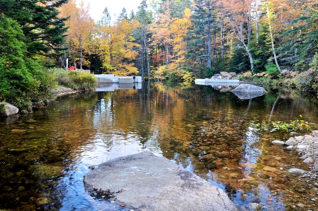
The small shallow impoundment above a water supply dam on the Zealand River.
Protecting the Road by Controlling the River
Further compromising the Zealand River was the use of extensive gabion in the early 1960s to try to reduce the impact of flooding on the road. Said to be the second oldest large-scale gabion-centric stream stabilization project in the United States, hundreds of feet of stone-filled wire mesh baskets were installed over roughly 1.5 miles of the middle river.
Gabion was used in the Zealand River to create what are referred to as revetment or retaining walls, grade-control sills, and groynes or deflectors. These structures are used to try to direct the flow of rivers and streams, prevent bank erosion, and lessen streambed scouring. Unfortunately, over time they tend to degrade, and as has happened on the Zealand River, can have the opposite effect of what was intended.
“I have been to this site multiple times over the years, but it still catches me a little bit by surprise when I see the scale of the project and the immensity of the mess it left behind. The Zealand River is a classic example of how overreaction to a flood can lead to projects that create decades of bad outcomes for rivers and the fish they contain.”
Over the years, much of the gabion on the Zealand River has failed. Retaining walls have pulled away from the bank and collapsed into the river, baskets have been emptied of rocks due to undercutting, and deflectors have been left high and dry. Small sections of gabion, likely remnants of old sills can be seen mid-river. Other sections, possibly old retaining walls or deflectors, are now yards away from the water.
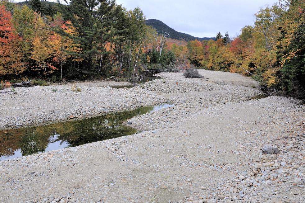
As sections of gabion wall fail and collapse into the river, they take dirt, gravel, rocks, and trees with them. In some places, deep pools have been filled as a result of failed gabion wall. In other places, the gabion structures have forced the river to one side, leaving expansive gravel flats in their wake. These areas are typically devoid of fish.
Less obvious is the impact the gabion is having on the Zealand River streambed. As the upstream end of failed gabion scour downward, the lower end rises as rocks moved from above collect below. This has created a step-like situation where consistent gradient has given way to slow, long, shallow pools in some areas. The streambed is deepening and narrowing in places which speeds up the current.
Much of the Zealand River and surrounding shoreline is now littered with collapsed gabion wall, fragments of gabion, empty rusted wire cages, and twisted jumbles of rusty wire. This is bad for the river, bad for the fish and wildlife that inhabit it, and bad for recreationists including anglers who have to navigate the obstructions and dodge the hazards.
Mother Nature Responds, Man Retaliates
When it comes to the Zealand River, the road is the top priority of the powers that be. This is especially true with regard to the municipal water supply, as without access to the dam they could not respond to problems or perform routine maintenance. Unfortunately, Mother Nature could care less and she occasionally threatens the road with an assist from the now badly compromised gabion work.
In 2017, tropical storm Philippe released a deluge on the White Mountains region of New Hampshire. The area got hit hard again in 2019. These events caused significant flooding and resulted in notable damage to many area rivers and streams, the Zealand River included. When the water receded, the river was barely recognizable. What man did after the fact to mitigate the damage may have been worse, and longer lasting.
According to the USFS, “the Town of Bethlehem worked on the banks of Zealand River after tropical storm Phillippe as well as a 2019 storm event.” They went on to say, “NHDES (NH Department of Environmental Services) issued the permit for the work, and Forest Service assisted in the 2019 effort with a portion of the funding and assisted in the permitting process but did not perform any of the on-the-ground work.” That USFS did not oversee work on their land is concerning.
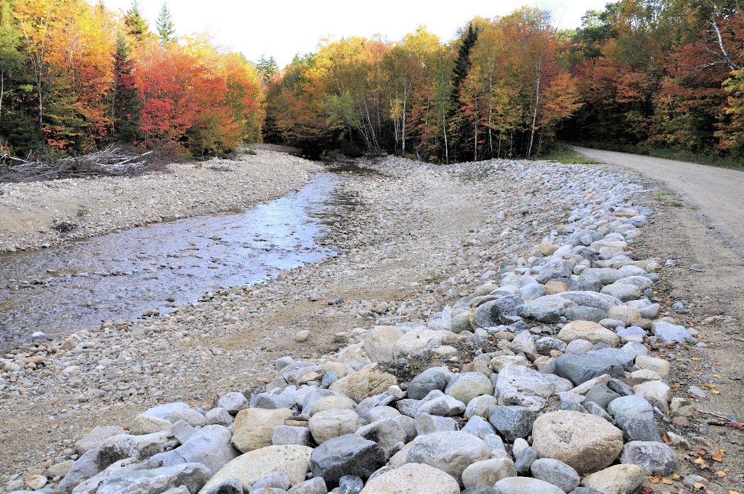
What was done to repair the road and try to prevent further intrusion of the river onto the road was environmentally and aesthetically damaging as well as technically unsound. At one point where the river had jumped the road, heavy equipment was brought in to bulldoze the streambed, riprap the outside bank, and reroute the flow into the inside corner. The outcome resembled a strip mining site.
Post-flood excavation done on the Zealand River to protect the road.
The process was repeated roughly ¼ mile upstream over a distance of a couple of hundred yards. The streambed was excavated, the outside bank was riprapped, and the stream was left wide open and sans any depth, structure or notable gradient. The result was a section of river literally devoid of fish, and left unaddressed likely to remain that way for decades to come.
Fishing Trumps Fish
The Zealand River is home to wild native brook trout. While the population bumps up and down from one year to the next due to weather conditions and angler traffic, wild native brook trout persist even during the worst of times and are always present. While small young fish represent the bulk of the fish caught, wild brook trout up to 6-inches are encountered but fish larger than that are rare.
Unlike National Parks where the National Park Service has jurisdiction over land and water as well as fish and wildlife, responsibility for the resources in National Forests is split between U.S. Forest Service, a branch of U.S. Department of Agriculture, and state fish and game. The former has jurisdiction over the land and water while the latter controls the fish and wildlife that inhabit it.
Like most rivers and streams in the area, New Hampshire Fish and Game (NHFG) manages the Zealand River under General Law regulations: Unrestricted tackle, 5-fish per day (or five pounds which is irrelevant in this case,) and no minimum length limit. The fishing season is open from January 1 through October 15, with angling traffic starting in May and running through the end of the season.
While all types of angling are represented on the Zealand River, as a result of the general tourism traffic, bait fishing is not at all uncommon on the river. The same holds true for harvest, and it is not at all unusual to see anglers leaving the river with stringers of fish. In fact, I believe it would be fair to say bait far outpaces flies and lures, and more anglers harvest fish than not.
Stocking Your Way Out of Trouble, or Not
As a result of easy access, heavy tourist traffic, and close proximity to three Forest Service campgrounds, two private campgrounds, informal campsites on nearby National Forest land, vacation homes, and rental cabins and motels, the Zealand River sees a lot of anglers. Based on what could fairly be called inconsistent fishing, especially near the road, the river cannot sustain the level of harvest NHFG allows.
As is often the case, when the recreational angling cannot hold up to what the powers that be want to allow, they resort to what is referred to as “supplemental stocking,” or deliberately and knowingly stocking over wild fish. In the case of the Zealand River, wild native fish. While this may provide temporary fishing for stocked trout, it stresses the wild fish population.
The Zealand River receives approximately 1,000 hatchery-raised brook trout a year. They are stocked in 4-5 spots over roughly two miles of the middle river easily accessed from the road. The stocked fish average 8 inches and 0.25 pounds, much larger than the wild fish found in the river. This results in competition for food and space, as well as some level of predation on wild fish.
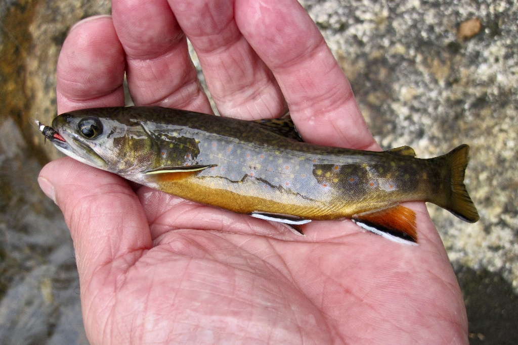
A wild native brook trout from the Zealand River.
I’m often asked how much a river or stream can take before it collapses. The Zealand River has taken a lot, and while down it is not out. The river is proof of nature’s resilience, and how much a resource can take before it collapses under the weight of man’s hand. Imagine what it could be if we stopped trying to tame it, stopped “managing” it, and stopped exploiting it.
The wild native brook trout population in the Zealand River bounces up and down from one year to the next, likely due to the fact that there is no longer any room for error. But it never ceases to exist, and when conditions are favorable it reminds us that it is still there and still viable. But the anglers keep hauling out fish and NHFG keeps stocking it to mask the problem.
Given half a break, the Zealand River could once again be a relatively healthy coldwater ecosystem. In spite of our best efforts to the contrary, wild native brook trout still persist, albeit in greatly reduced and radically fluctuating numbers. The pieces are all there: Protected public land, cold clean water, and enough wild native brook trout to repopulate the river. It just needs some help…
For the first time in decades there is some good news in regard to the Zealand River. USFS is scheduled to begin removing some of the failed gabion this summer. Their primary goal is reconnecting the river to its historic floodplain. This will help heal the river in the immediate vicinity of the work, as well as lessening further degradation downstream to some degree, and possibly a high degree.
While some will see this as a happy ending to a sad story, I see it as a beginning of a new story. With any luck, this could be the point where those charged with protecting the river shift from a pattern of abuse and exploitation to a pattern of reasonable use and preservation. The challenge will be getting NHFG, Town of Bethlehem, anglers, and others to follow suit.
While reconnecting the Zealand River to its floodplain is one of the most impactful things we can do, many other sections of failed gabion should be removed as well. To lessen damage to the riparian area and streambed resulting from the use of heavy equipment, Native Fish Coalition would like to see an effort using volunteers to manually cut away wire and allow the rocks to fall back into the streambed.
It would also help to restore some banks and streambed damaged as a result of attempts to mitigate flood damage and protect the road. In many places, the Zealand River has been left without any in-stream structure which has resulted in long featureless stretches that are virtually devoid of fish. The addition of large wood debris and large rocks could help reestablish pools and meanders.
As for protecting the wild native brook trout, this falls squarely on the shoulders of NHFG. With miles of heavily stocked easy access water in the area that is open to bait and liberal harvest, the Zealand River should be managed as a wild fishery. For this to happen, the New Hampshire fish conservation community will have to unite under a common cause and work together to restore this unique resource.
The story of the Zealand River is still being written. As soon as we close one chapter, we open another. While most of the previous chapters have been bad news centric, the next chapter may offer some long overdue good news. Hopefully we can build on what USFS looks to do with regard to reconnecting the river to its floodplain and take the next steps toward a holistic healing of the Zealand River.
There are many lessons to be learned in regard to the Zealand River. Easy access usually comes at a cost, and the resource pays the price. When we build roads too close to streams we invite problems, and in the end neither truly wins. We must also show restraint when rivers encroach on roads, and act calmly and carefully. Lastly, we need to stop turning to hatcheries to try to fix our fishing woes as this is a temporary band-aid not a cure.


