Using Google Maps to Find Early Season Schoolies in New England
Finding early season stripers on the fly can seem like an insider sport and daunting for the occasional angler in New England. With the amount of water available for action, it can be a game of hit or miss, even though spring fishing can be the most productive. The only people who seem to have consistent success are those who dedicate hours on the water fishing guides, the retired, or the gainfully unemployed.
The good news for the rest of us is that there exists Google Maps. Yes, Google Maps. An internet connection and a smart phone can provide most of the information you will need to pick your spring hot spots. With an eye trained to read the right conditions from an aerial view, possibilities for striper success along the 473 miles of New England coast suddenly come into focus. You’ll still need a mediocre cast and a box full of clousers, but knowing how to read satellite images of coastal waters can make any person a fly fisherman in the know.
Here are five characteristics to search from the air:
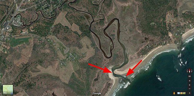
1. Find Small Tidal Creeks and Rivers
Look where there is food. Striped bass are predators and their search for food spurs their spring migration. After long winter months, early season fish are in search of the many alewives, menhaden and shad that fill coastal creeks and rivers. Scanning an aerial photo of the coast, you’ll find an abundance of this ideal baitfish habitat from Connecticut to Maine.
In fact, so much water exists that you be wondering which place to begin. The trick for finding the ideal spot lies in identifying areas that are right-sized for the average fly fisherman. Avoid wide rivers, canals, and large inlets. If the water seems too large and unmanageable for you to fish, it most likely is. Experience has taught me that while fish are present in most coastal rivers, they’re difficult to catch consistently with a fly rod in a large body of water.
Use geography and the underwater terrain of these small coastal waterways to your advantage. Striped bass will use these natural boundaries to capture passing fish, which makes predicting their location easier than guessing in a large body of water. The ideal spot has a current and a narrow, deep passage with a steep drop off from a sandbar or shore.
These conditions funnel the bait fish through a narrow trap. People laugh when I make the comparison, but I read water for striped bass like I do for trout. If I see eddies, deep pools, and channels, I normally can predict where the fish lie. It’s simply a matter of placing a fly in their feeding lane.
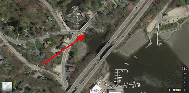
2. Look for Natural Breaks between Fresh and Salt Water
You may be asking yourself, “how can I see the line between fresh and saltwater from the air?” The answer usually lies in form of a dam, natural or man-made. Most of New England’s rivers were dammed during the colonial period to harness their hydro power, and many of these dams were placed on naturally occurring areas that separated fresh and salt water.
It’s not that stripers necessarily prefer this boundary water because of the saline concentration, but rather because they use these areas to ambush bait fish briefly resting before continuing their journey upstream to spawn. The productivity of these areas can often be surprising, especially if you coincide with the late alewife runs. Bass stack in deep pools and behind rocks waiting for passing prey, and will often hit a deep sinking fly that flashes before their eyes.
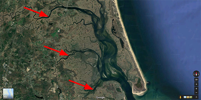
3. Look for Large Marshes that Feed Creeks and Rivers
For me, the larger the marsh that feeds the creek, the more baitfish that are generally present in the local ecosystem. More food means more stripers. As you scout the coastline from above, look for the size of wetland area that feeds it. You’re looking for the many braids of small creeks and estuaries that eventually come together to feed the main stem of the river. These provide prime habitat for baitfish.
Bring your waders and don’t be afraid to travel up river and explore these smaller braids. I hooked my largest fish last year nearly 3 miles from the river mouth in a creek no wider than 30 feet across. Schoolies, and as the season progresses, large fish, remain in deep pools even with the changing tides. Finding an upstream honey hole can offer hours of fun, and you’ll most likely lose the crowds that can build at the river mouth.
4. Start South and Work North
You can’t catch fish that haven’t arrived. Most bass migrate to New England waters, and stripers that migrate come from the south, most likely from one of three spawning areas – the Hudson River, the Delaware River or Chesapeake Bay. Bass appear in Connecticut and Rhode Island in April. The southern Cape begins to see steady action as May begins while fish appear in New Hampshire and southern Maine in numbers several weeks later. Keep this fact in mind as you scan aerial maps for locations. You may find the perfect geographic conditions, but may be too early for the migration. If you have the time to travel to places such as Buzzards Bay or northern Cape, May fishing can be spectacular offering 30, 40, and even 50 fish days. But, if you don’t have the time to make the drive, it may be simply a waiting game. By the end of May, even southern Maine should have an abundance of fish in its creeks and rivers.
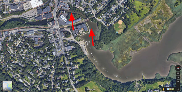
5. Don’t be Afraid of Urban Areas
Most of us associate seclusion with productive fishing – less people means more fish. But, the truth is, while there may be many passersby, there are most likely very few people who actually fish for the striped bass that travel inner urban waterways. If you don’t mind the buzz of traffic or the occasional sunken tire, creeks in even the most developed creeks and rivers can produce great numbers of fish.
To identify these urban holes, use the same criteria in points one through four. You’ll be looking for creeks with a flow, deep pools, and ideally for a place where there is a break between the fresh and salt water. Last year, with my kayak, I paddled into a Boston suburb where I caught a seemingly limitless supply of schoolies. I worked the fast water flowing from beneath a dam, and picked up a fish on nearly every quarter downstream swing of my weighted fly. I was delighted to discover such natural abundance in a place so influenced by man. And, I didn’t see another angler the entire day.
Technology has opened up new fishing possibilities for everyone. Don’t let yourself be confined to information gleaned from local bait shop chatter. Get in the car and explore. With a computer, a little research, and eye for the right geographic conditions, you will discover more fishing options, and fish, than weekends in these warming days of spring.


